
Tip-and-Cue Fills Knowledge Gaps and Optimizes Constellations
The Earth is constantly in motion. Construction projects break ground and finish, ships flow through ports, aircraft deploy to new bases, and supply chains shift across continents. For governments and commercial entities, the ability to track these changes and understand their implications is both a challenge and an opportunity.
Partial views, partial truths
Today’s satellite constellations collect hundreds of terabytes of imagery each day, mostly from medium-resolution (3–20 meter) multi-spectral imagers. Each image captures a wide swath of the Earth, and sometimes each constellation can even re-image the same location multiple times in a single day.
Their individual strength lies in cadence. With daily revisit rates, they can detect when something has changed in near real time: a new structure appears, vehicles cluster in a usually quiet area, or crops decline unexpectedly.
But cadence often comes at the cost of clarity. While these systems can confirm that something changed, they often can’t determine what changed or how. For smaller objects and subtle kinds of activity, the picture remains incomplete.
Clarity at a cost
Conversely, very-high-resolution (10-50 cm) satellites collect high-fidelity imagery that can provide clarity into pieces of machinery, models of vehicles, and types of materials. With that kind of detail, analysts can not only confirm that change occurred, but also classify the specific activity, stage, or equipment type driving it.
The tradeoff for these satellites is cost, coverage, and availability. High-resolution satellites are fewer in number, making them slower to revisit the same site, and more expensive to task. They deliver exquisite detail, but they can’t be everywhere at once. A smaller visible footprint means you can clearly see the activity at an airfield, but not the city surrounding it. Using them as the primary monitoring tool would quickly drain budgets and leave critical activity missed in between passes.
Tip-and-cue to the rescue
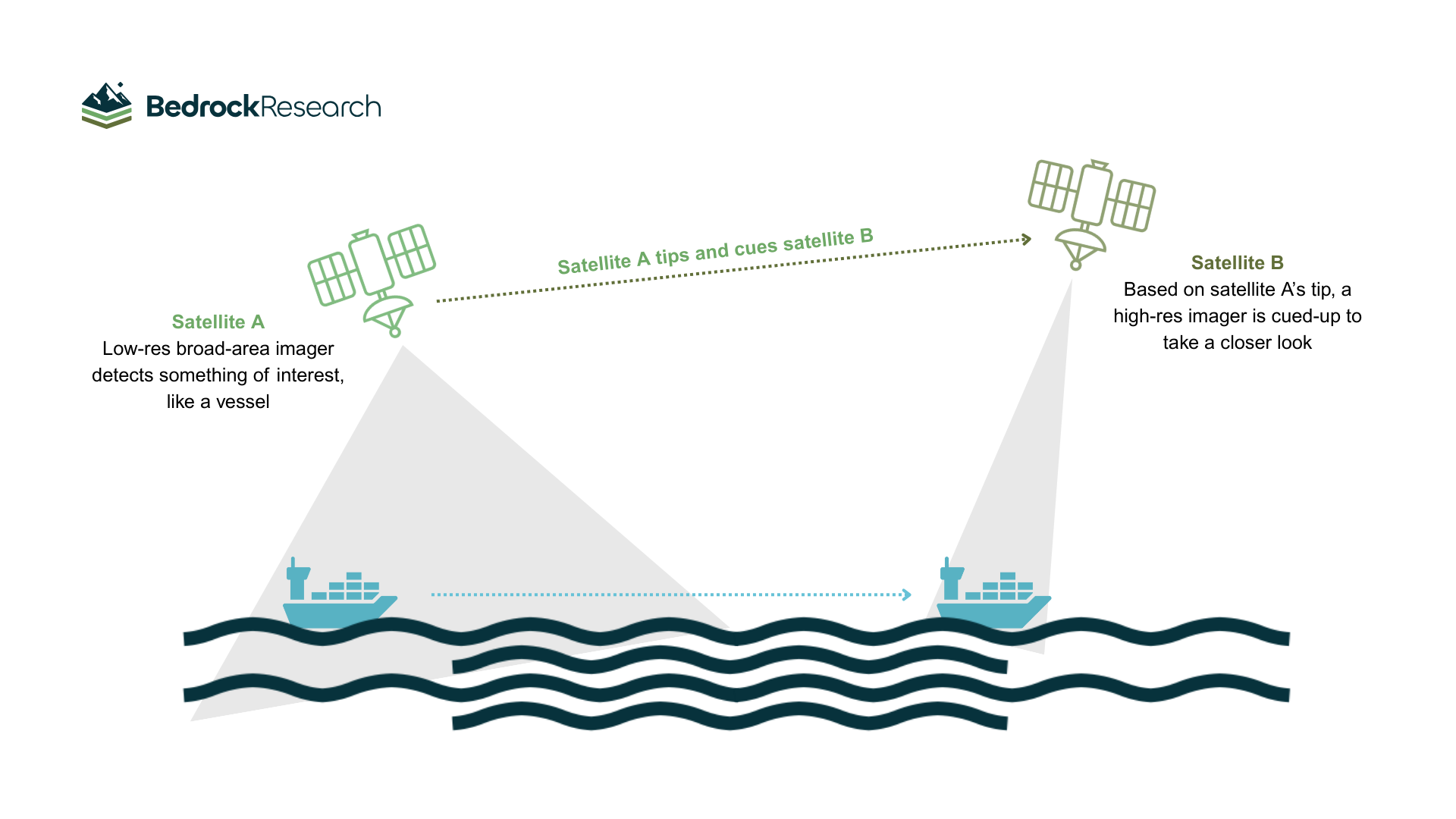
This is where the workflow of tip and cue becomes transformative:
A broad-area, high-revisit, persistent sensor provides the tip: a signal that something noteworthy has occurred.
That signal then triggers, or cues, a higher-resolution or specialized sensor to collect sharper, more detailed data over the same area.
Take the example of a construction site. A high-revisit imager, like those from Planet or Wyvern, might detect new activity. It clearly shows change but may lack the resolution to identify what’s happening on the ground. That tip then cues a higher-resolution satellite, such as Albedo or Capella, to re-image the site. With pixels small enough to distinguish between types of equipment and see tire tracks, analysts can confirm the type of equipment present and assess whether machinery is being staged ahead of a major project milestone.
Tip-and-cue workflows extend across modalities. A multispectral sensor might cue an infrared sensor to capture the same site at night. SAR satellites, like those from Capella or Umbra, can image through clouds for continuity. Even RF or SIGINT collectors can add communication patterns that correlate with observed activity.
By continuously scanning broad areas with proliferated, moderate-resolution constellations, and only cueing exquisite assets when warranted, analysts and automated workflows can choreograph collections in a way that maximizes each system’s strengths while conserving resources.
AI as a force multiplier
Historically, broad-area monitoring has been constrained by human bandwidth: analysts draw boundaries, hand-flag anomalies, and cross-reference data manually, but AI and machine learning are changing the equation. By modeling a site’s “baseline” behavior (its normal vehicle flow, seasonal crop cycles, or routine port activity), AI can automatically detect deviations that matter. The model tips us off when activity is unusual, narrowing the field so that high-resolution sensors and human expertise focus only where they add the most value.
At Bedrock, our geospatial foundation model powers this workflow. Trained on vast, multi-modal data, it aligns imagery, signals, and other inputs into a shared representation of the world.
When our model first flags possible construction in a moderate-resolution image, it then immediately contextualizes the finding, compares it against historical activity, checks for corroborating SAR or RF signals, and prioritizes whether a high-resolution follow-up is justified. The result is a human-on-the-loop system that reduces noise, highlights what matters, and gives analysts superhuman reach.
Making tip and cue a reality
Persistent monitoring at scale is not only a defense or intelligence challenge. Commercial sectors, from energy to insurance to logistics, also depend on the ability to anticipate disruptions, verify activity, and measure change.
The vision is simple:
Broad-coverage satellites ensure we never miss a change
High-resolution systems confirm and characterize the changes that matter
Bedrock’s geospatial foundation model acts as the connective tissue that finds the signal in the noise
The technology to rapidly fuse and analyze multi-source data exists today. Bedrock is actively building relationships with global data providers to simplify and expedite the tip and cue process in order to better serve our customers and their missions. But just as no one sensor can provide a complete picture or solve every monitoring problem, making tip and cue a reality will take a concerted effort on behalf of providers and consumers to build out the connections and processes to make it a truly operational workflow.
The world is always changing. With the right combination of sensors and AI, we can ensure that important change never goes unnoticed, and more importantly, that it is understood.