From Pixels to Protection: Bedrock Powers Environmental Monitoring

Situational awareness for a changing planet

Environmental

From deforestation in the Amazon to illegal fishing in the South China Sea, and from coastal erosion to wildfire spread, environmental challenges are accelerating in frequency, complexity, and impact. Whether you're a conservation group, a regulatory agency, or a global insurer, one need is shared across sectors: constant, trustworthy visibility of what’s happening on the ground.

Traditional monitoring methods such as satellite imagery, field reports, or drone flights offer value, but the coverage is fragmented and often delayed. Meanwhile, bad actors exploit cloud cover, AIS silence, and data delays to continue their operations undetected.

At Bedrock, we’ve developed a real-time, multi-sensor monitoring solution designed to expose critical environmental events as they unfold. This helps stakeholders act sooner, respond smarter, and safeguard the planet’s most vulnerable populations and valuable resources.

The multi-modal edge

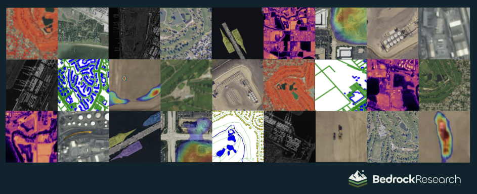
Bedrock fuses diverse sensor streams (optical, radar, thermal, RF, hyperspectral, and open-source) to produce one trusted picture of environmental change.

Unlike most monitoring services that rely on a single data stream, we integrate all of them into one fused intelligence layer. This approach detects change earlier, interprets it more accurately, and explains why it matters. It transforms siloed data into high-confidence insight for environmental agencies, NGOs, disaster response teams, and climate risk analysts.

Multi-Modal
Data Type What It Reveals Blind Spots (when used in isolation)
High‑resolution optical Tree canopy loss, infrastructure expansion, illegal mining pits, river dredging, shoreline retreat Obstructed by clouds and darkness, limited revisit frequency
SAR (Synthetic Aperture Radar) Flood extent, landslides, deforestation through clouds, surface deformation Can be difficult to interpret without context, motion blur
Thermal / Midwave Infrared (MWIR) Active wildfires, burn scars, flare sites, heat from illicit activity Low contrast in direct sunlight, coarser spatial resolution
AIS & RF Geolocation Illegal fishing, vessel loitering, spoofed locations, dark ship movement Signal jamming, intentional AIS silence
Hyperspectral / Multispectral Vegetation health, pollution detection, water quality, illegal waste discharge Low cadence, heavy data volume, cloud sensitivity
Open‑source Intelligence (OSINT) News, local reports, social media, community alerts, permit updates High noise‑to‑signal ratio, needs cross‑validation

High‑resolution optical

Reveals
Tree canopy loss, infrastructure expansion, illegal mining pits, river dredging, shoreline retreat
Blind Spots (solo)
Obstructed by clouds and darkness, limited revisit frequency

SAR (Synthetic Aperture Radar)

Reveals
Flood extent, landslides, deforestation through clouds, surface deformation
Blind Spots (solo)
Can be difficult to interpret without context, motion blur

Thermal / Midwave Infrared (MWIR)

Reveals
Active wildfires, burn scars, flare sites, heat from illicit activity
Blind Spots (solo)
Low contrast in direct sunlight, coarser spatial resolution

AIS & RF Geolocation

Reveals
Illegal fishing, vessel loitering, spoofed locations, dark ship movement
Blind Spots (solo)
Signal jamming, intentional AIS silence

Hyperspectral / Multispectral

Reveals
Vegetation health, pollution detection, water quality, illegal waste discharge
Blind Spots (solo)
Low cadence, heavy data volume, cloud sensitivity

Open‑source Intelligence (OSINT)

Reveals
News, local reports, social media, community alerts, permit updates
Blind Spots (solo)
High noise‑to‑signal ratio, needs cross‑validation
You no longer need five dashboards and a data science team to connect the dots. Bedrock does it for you.

From reactionary to anticipatory

In today’s rapidly changing ecosystems, speed and clarity define the difference between proactive conservation and irreversible damage. Bedrock’s environmental monitoring solutions are powered by a data fusion engine and two purpose-built AI pistons: anomaly detection and semantic annotation. Together, they surface meaningful environmental changes faster than traditional monitoring cycles and explain exactly why they matter for early intervention, resource protection, and long-term resilience planning.

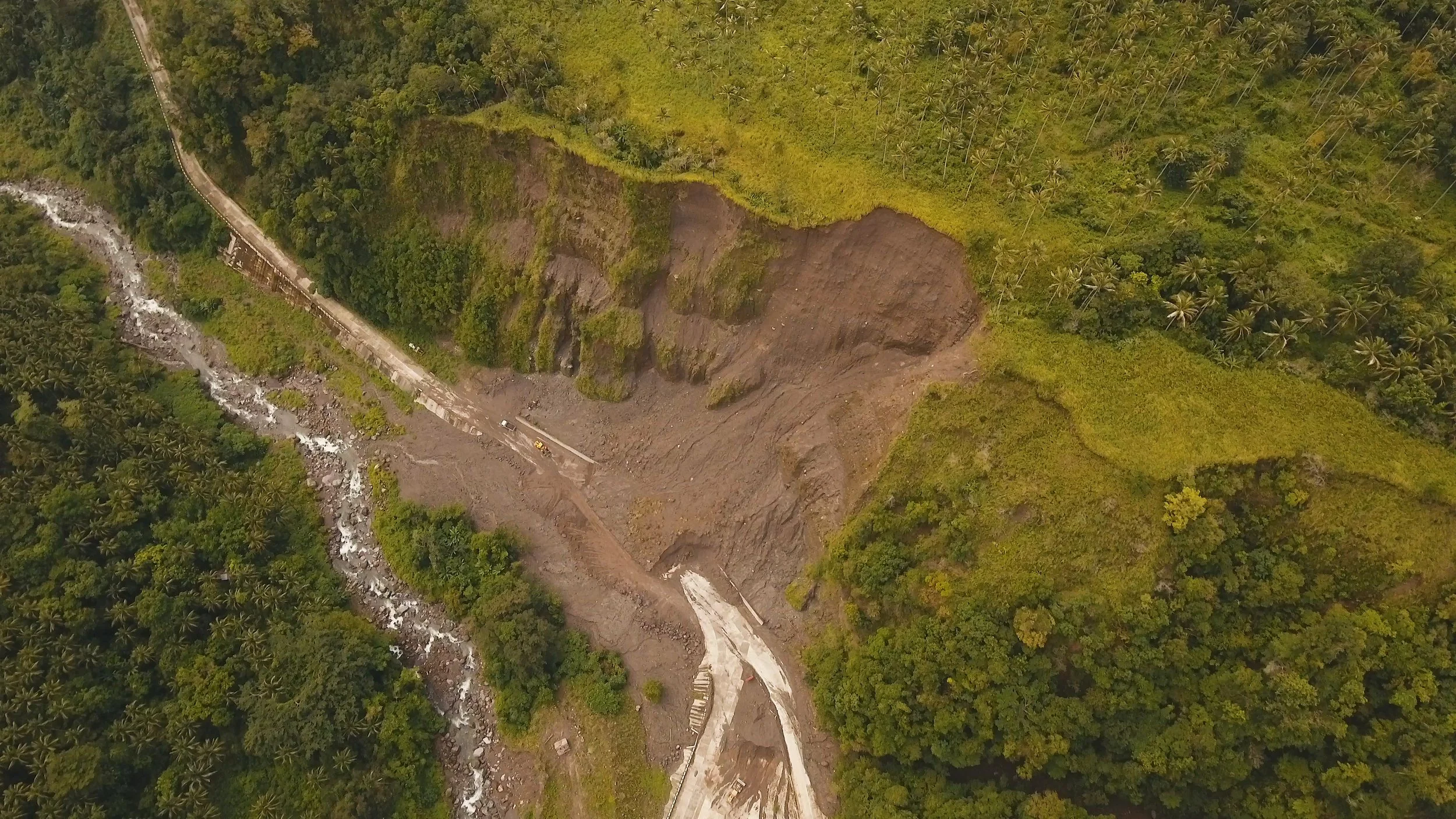
  1. Anomaly detection: Real-time data inputs are compared against both a last-known-good baseline and a long-term-average baseline to distinguish expected changes from abnormal, attention-worthy ones. With this understanding, it flags environmentally significant anomalies such as sudden deforestation, unauthorized road construction, un-permitted mining activity, illegal burn scars, or unexpected changes in river courses.

  2. Semantic annotation: Using small-sample learning, we train computer vision models to recognize the subtle environmental features and activities you can’t afford to miss, and must understand. These include the spread of illegal encampments in protected forests, unregistered mining operations, unauthorized coastal developments, micro heat changes indicating flare activity or fire ignition, and dark vessels operating in marine conservation zones.

Together, anomaly detection shows what and where pertinent activity is occurring, while semantic annotation explains how it changed and why it matters.

Detect leading indicators, such as the arrival of heavy machinery, and monitor deforestation across broad areas, as seen here in the Yucatan.

Your trusted 24/7 environmental monitoring partner

Bedrock reduces detection timelines from days to minutes. It provides continuous global coverage without the need for new sensors, flights, or field visits. Here’s how our solution supports environmental monitoring, protection, and resilience:

Operational Challenge Bedrock Insight Impact
Illegal logging Detects canopy thinning, road‑cutting, and staged wood loads near protected forests Mobilize enforcement and support investigation
Landslides Detect earth settling and subtle shifts in ground surface Protect vital rail lines and highways in mountainous and coastal areas
Coastal erosion Tracks shoreline loss, sandbar movement, and rising waterlines with SAR and optical Prioritize restoration projects, safeguard infrastructure
Illegal fishing Identifies dark ships, AIS spoofing, vessel clustering in restricted zones Enable interdiction and strengthen marine protection enforcement
Wildfire ignition and spread Uses thermal cues and wind modeling to map fire fronts, hot spots, and project spread Issue early warnings and optimize firefighter deployment
Flooding and storm surge Measures water movement, sediment color shifts, and infrastructure submersion Enable early response and inform climate resilience planning

Illegal logging

Bedrock Insight
Detects canopy thinning, road‑cutting, and staged wood loads near protected forests
Impact
Mobilize enforcement and support investigation

Landslides

Bedrock Insight
Detect earth settling and subtle shifts in ground surface
Impact
Protect vital rail lines and highways in mountainous and coastal areas

Coastal erosion

Bedrock Insight
Tracks shoreline loss, sandbar movement, and rising waterlines with SAR and optical
Impact
Prioritize restoration projects, safeguard infrastructure

Illegal fishing

Bedrock Insight
Identifies dark ships, AIS spoofing, vessel clustering in restricted zones
Impact
Enable interdiction and strengthen marine protection enforcement

Wildfire ignition and spread

Bedrock Insight
Uses thermal cues and wind modeling to map fire fronts, hot spots, and project spread
Impact
Issue early warnings and optimize firefighter deployment

Flooding and storm surge

Bedrock Insight
Measures water movement, sediment color shifts, and infrastructure submersion
Impact
Enable early response and inform climate resilience planning

Our modular, AI-driven solution ensures 99 percent uptime, global accessibility, and end-to-end encryption. All insights are validated by multiple sensor streams and reviewed with a human-in-the-loop quality assurance step. When you receive a signal, you can act with confidence.

Whether you’re monitoring a rainforest, coral reef, protected wetland, or climate-vulnerable community, Bedrock helps you understand what’s changing, why, and what to do next.

Learn How Bedrock Can Support Your Misson