

From Pixels to Production: Safeguarding Energy Assets
Monitoring mandates just got tougher
Whether you’re an upstream operator accelerating spud-to-first-oil, a midstream integrity lead keeping right-of-ways clear, or an HSE manager preparing for the next PHMSA audit, the message is the same: you need eyes on every asset, every day.
Traditional surveillance like scheduled flyovers, drive-by patrols, and SCADA alarms still matter, but they’re episodic and siloed. Meanwhile, regulators, shareholders, and trading partners demand verifiable proof of environmental stewardship, leak prevention, and plug-and-abandon compliance. Reacting days or weeks after a hydrocarbon release is no longer acceptable when minutes can mean millions.
At Bedrock, we've built a real-time monitoring solution that does the heavy lifting, keeping analysts focused on mission-relevant activity and decision makers steps ahead of the curve.
The multi-modal edge
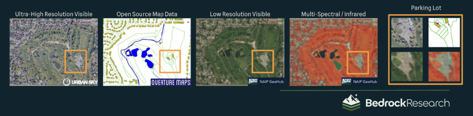
Multi-sensor georegistration, coupled with Geospatial AI, fuses the data you collect today with open source or proprietary vector data and historical imagery to extract additional context and deliver high-confidence reporting.
Unlike most pixel-level monitoring services, we focus on fusing multiple data together in order to create a seamless force multiplier that provides intelligence into how and how significantly change has occurred. In other words, our solution focuses teams on areas of mission-relevant change, and offers rich, predictive insights in ways that single-data offerings can’t.
Other monitoring services are often limited to one or two types of data inputs, which can cause interruptions from clouds and darkness, or expose spectral blind spots.
“You no longer need five dashboards and a data science team to stitch the story together; we do it for you.”
We remove blind spots by ingesting them all—plus AIS, ADS-B, drone imagery, field photos, open-source data, and your own SCADA events—into one convenient place. Our data fusion engine cross-validates signals, reducing false positives and delivering a ‘single pane of glass’ for asset and operational integrity.
From reactionary to anticipatory
When it comes to safeguarding energy assets, speed and specificity are everything. Our monitoring solution hinges on two purpose-built AI pistons—anomaly detection and semantic annotation—that work together to surface critical events faster than any inspection cycle and shed insight into why they matter to production uptime, safety, and compliance.
Anomaly detection: Real-time data inputs are compared against both a last-known-good baseline and a long-term-average baseline to distinguish expected changes from abnormal, attention-worthy ones. With this understanding, it flags ground disturbance, pad build-out, or vegetation stress along gathering lines, highlighting areas of focus before the next inspection cycle.
Semantic annotation: Using small-sample learning, we train computer-vision models on the events you rarely see but absolutely must catch and understand: rainbow sheens in settling ponds, unauthorized tie-ins, makeshift storage tanks, or micro-methane plumes invisible to RGB..
Together, anomaly detection tells you what and where something changed and semantic annotation drills into how it changed and why it matters to your production and compliance KPIs.
Coupled with our semantic annotation, Urban Sky imagery exposes important changes like pad development or reclamation. Bedrock's monitoring services can be applied to over 1,000s of sites with minimal human intervention required.
Your trusted 24/7 operational partner
Our multi-sensor fusion slashes detection latency from days to hours, shrinking spill volumes and litigation exposure, while delivering 100% coverage across every terrain, from onshore oil fields to sprawling wind farms and offshore platforms, without extra boots or flight hours. Here are some of the ways our insights help energy operators:
Partnering with Bedrock means staking your operations on a monitoring solution engineered for rock-solid reliability. Our AI-fueled data fusion engine runs on a hardened, cloud-native architecture with 99.9% uptime SLAs, multi-region redundancy, and end-to-end encryption that keeps proprietary field data secure. Everything can be cross-validated by multiple sensors and a human-in-the-loop QA process, so you, and your regulators, can trust the signal, not chase noise.